
Heading into the evening, there was a chance for a few storms to develop as the dryline advanced across North Texas. There was a Level 1 (Marginal) to Level 2 (Slight) risk for severe thunderstorms.
Thunderstorms have moved out of North Texas and the rest of the night will be tranquil.
Watch NBC 5 free wherever you are
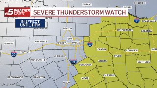
At about 4:15 p.m., the National Weather Service issued a Severe Thunderstorm Watch for areas east of Interstate 35/I-35E and east of Highway 75 near the Red River until 11 p.m. The watch includes Dallas, Ellis and Collin counties but does not include Denton, Johnson, Tarrant and Grayson counties.
At 5 p.m., the dryline was crossing the I-35 corridor with scattered thunderstorms stretching from Italy south to Waco. The NWS said the cap remains strong over the Metroplex and that the area most likely to see storms will be to the south and southeast. Behind the dryline, gusty winds up to 40 mph can be expected.
Get top local stories in DFW delivered to you every morning with NBC DFW's News Headlines newsletter.

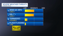
The NWS said where storms develop conditions are favorable for scattered hail up to tennis ball size with wind gusts to 70 mph. A tornado or two is possible.
The storms began developing at about 4 p.m. in the DFW area and quickly pushed eastward.
The activity will exit eastern North Texas by 9 p.m. Please keep an eye to the sky and stay WEATHER AWARE!

Local
The latest news from around North Texas.
Stay informed during severe weather season with our news and weather apps for phones, tablets and TVs. On phones and tablets, choose the breaking and weather alerts you want to receive. More details and links to app stores are here.