An active pattern continues across North Texas for the rest of the week with rounds of rain and storms.
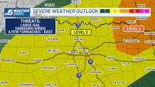
Additional storms are expected into Friday. The Storm Prediction Center has much of North Texas included in a level 2 risk for severe weather with a higher risk (level 3) of severe storms north and east of DFW.
Watch NBC 5 free wherever you are
While the main threats will be large hail and damaging winds. A few storms east of the Metroplex could bring a few tornadoes.

Get top local stories in DFW delivered to you every morning with NBC DFW's News Headlines newsletter.
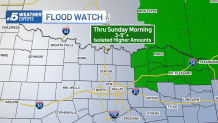
The heaviest rain is set to arrive late Friday into Saturday morning. A flood watch has been posted for areas Northeast of DFW thru Sunday morning.

Rain totals could exceed 2 inches in some locations, with the highest rain total expected in locations north and east of DFW.

By Sunday, the pattern begins to dry out, with sharply cooler air pushing in behind a cold front.
Below-normal temperatures will stick around for a couple of days, featuring lows in the 40s and highs only in the 60s.


