

Our first hurricane of the season continues to intensify in the Atlantic. Beryl strengthened into a major category 4 hurricane on Sunday afternoon with max sustained winds at 130 mph. The storm is forecast to bring life-threatening winds and storm surge to the Windward Islands as an extremely dangerous hurricane.
A Hurricane Warning is in effect for Barbados, St. Lucia, St. Vincent, Grenada and the Grenadine Islands.
A major hurricane is considered Category 3 or higher, with winds of at least 111 mph (178 kph). On Saturday afternoon, Beryl was a Category 1 hurricane, marking the farthest east that a hurricane formed in the tropical Atlantic in June, breaking a record set in 1933.

Get DFW local news, weather forecasts and entertainment stories to your inbox. Sign up for NBC DFW newsletters.

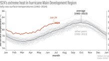
The location of development of this storm is usually reserved for storms later in August and September. However, unusually warm water in this area has made it more favorable for the formation of storms. Water temperatures in the tropical Atlantic this year have been well above normal.
Current water temperatures are more representative of temperatures found in late August. Warm water is one of the key ingredients for the development of tropical systems.
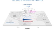
Warm ocean water is just one of the reasons why NOAA (The National Oceanic and Atmospheric Administration) is predicting an active Atlantic hurricane season. Another major factor is La Nina. The El Nino pattern that was present for much of the last year has faded. In its place is a developing La Nina. In a La Nina pattern, the upper-level winds over the tropical Atlantic are weaker leading to less wind shear and more favorable conditions for storms to develop.
Stay tuned to what will likely be an active tropical season.

