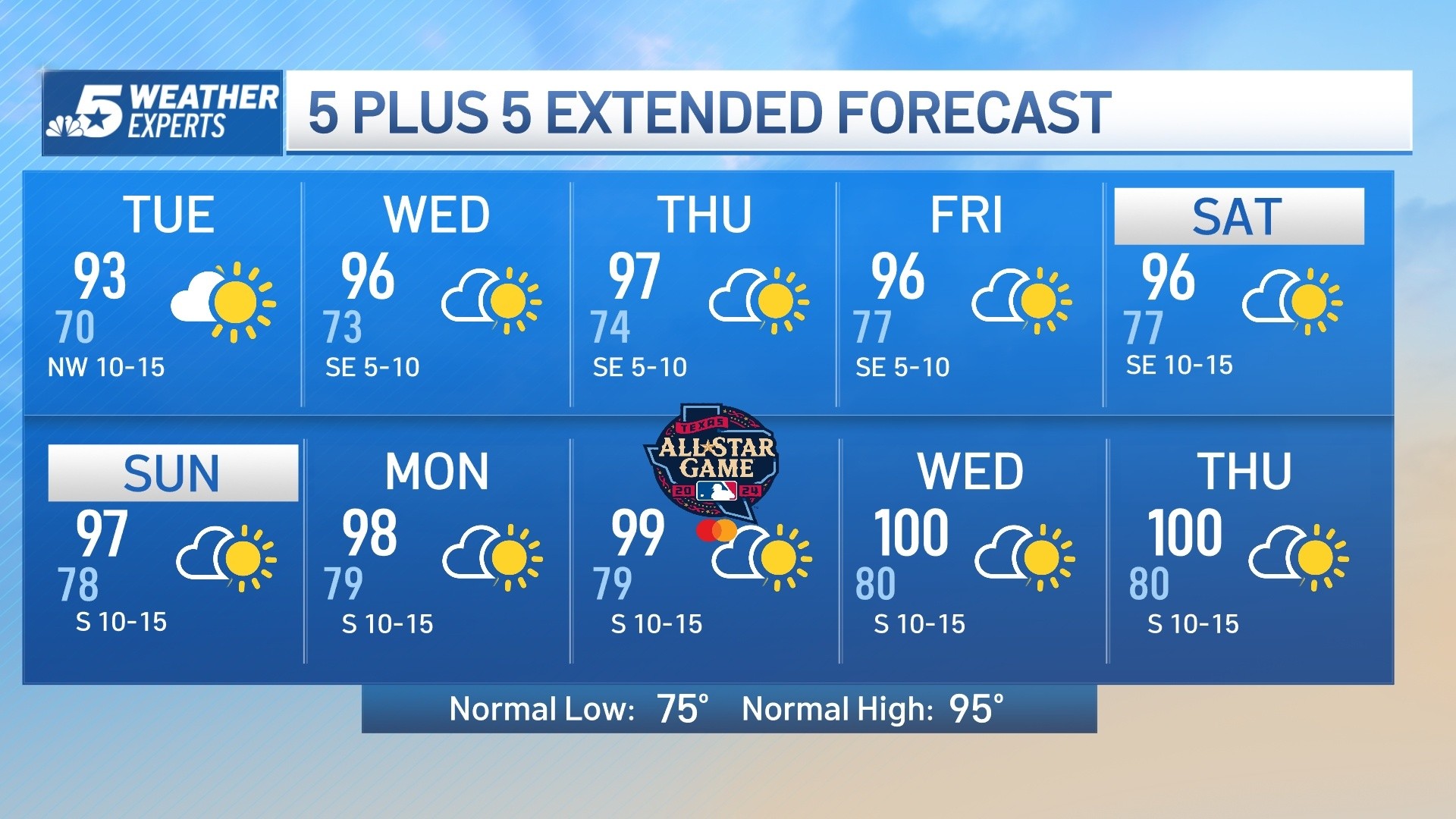
An unusually strong ridge of high pressure in the jet stream pattern is resulting in very warm temperatures for this time of year. In fact, the pattern will become even more amplified heading into the weekend. This means record highs will be within reach. Record highs for DFW for both Saturday and Sunday are 97. At least the humidity will remain low, making it more comfortable, and there will be a nice breeze.
An unusually strong ridge of high pressure in the jet stream pattern is resulting in very warm temperatures for this time of year. In fact, the pattern will become even more amplified heading into the weekend. This means record highs will be within reach. Record highs for DFW for both Saturday and Sunday are 97. At least the humidity will remain low, making it more comfortable, and there will be a nice breeze.
A strong fall cold front will by Monday, bringing in cooler weather, but unfortunately no rain. Highs next week will be in the 70s and low 80s.
Click here to see all North Texas weather alerts
Get top local stories in DFW delivered to you every morning. Sign up for NBC DFW's News Headlines newsletter.
Latest Forecast:
FRIDAY: Mostly sunny, breezy, and very warm. High: 91. Wind: S 10-15 mph.
TONIGHT: Mostly clear. Low: 68. Wind: S 10 mph.
SATURDAY: Mostly sunny with near-record heat. Low: 68. High: 94. Wind: SSW 10-15 mph.
SUNDAY: Mostly sunny with near-record heat. Low: 68. High: 96. Wind: SW 10-15 mph.
MONDAY: Mostly sunny and not as hot. Low: 65. High: 86. Wind: N 10-15 mph.
TUESDAY: Mostly sunny and pleasant. Low: 59. High: 80. Wind: NE 10-15 mph.
WEDNESDAY: Mostly sunny and seasonably warm. Low: 53. High: 77. Wind: SE 10-15 mph.
THURSDAY: Mostly sunny, breezy and seasonably warm. Low: 55. High: 78. Wind: SE 10-20 mph.
FRIDAY: Partly cloudy, breezy and warm. Low: 59. High: 82. Wind: SE 10-20 mph.
SATURDAY: Partly cloudy, breezy and warm. Low: 62. High: 82. Wind: SE 5-10 mph.
SUNDAY: Partly cloudy and cooler with a 20% chance of a storm. Low: 59. High: 76. Wind: N 10-15 mph.