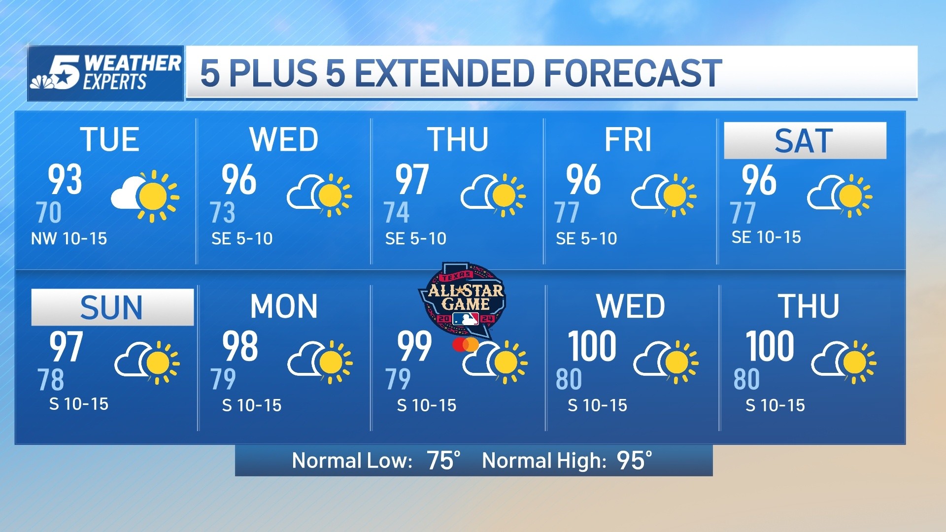
Above normal temperatures will stick around this week with high temperatures in the mid to upper 90s through Friday. The normal high for DFW this time of year is in the upper 80s. An unusually strong upper level ridge of high pressure is responsible for this hot weather pattern.
Above normal temperatures will stick around this week with high temperatures in the mid to upper 90s through Friday. The normal high for DFW this time of year is in the upper 80s. An unusually strong upper level ridge of high pressure is responsible for this hot weather pattern.
This ridge will begin to break down by Sunday and into next week allowing for a slight temperature drop. Fall begins Sunday, September 22nd at 7:44 a.m.
Click here to see all North Texas weather alerts
Get top local stories in DFW delivered to you every morning. Sign up for NBC DFW's News Headlines newsletter.
Latest Forecast:
WEDNESDAY: Mostly sunny and hot. High: 95. Wind: SE 5-10 mph.
TONIGHT: Mostly clear. Low: 76. Wind: SE 5 mph.
THURSDAY: Mostly sunny and hot. Low: 76. High: 95. Wind: SE 5-10 mph.
FRIDAY: Mostly sunny and hot. Low: 76. High: 97. Wind: SE 5-10 mph.
SATURDAY: Partly cloudy and very warm. Low: 76. High: 94. Wind: SE 5-10 mph.
SUNDAY (FALL BEGINS): Partly cloudy and very warm. Low: 75. High: 92. Wind: SE 5-10 mph.
MONDAY: Partly cloudy and warm. Low: 70. High: 89. Wind: SE 5-10 mph.
TUESDAY: Mostly sunny and warm. Low: 70. High: 89. Wind: SE 5-10 mph.
WEDNESDAY: Mostly sunny and warm. Low: 68. High: 85. Wind: N 5-10 mph.
THURSDAY: Mostly sunny and warm. Low: 68. High: 86. Wind: NE 5-10 mph.
FRIDAY: Mostly sunny and warm. Low: 67. High: 86. Wind: NE 5-10 mph.