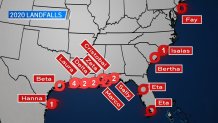
Eta has made another landfall!
Tropical Storm Eta made landfall Thursday morning near Cedar Key, Florida, at 4 a.m. EST. Maximum sustained winds were 50 mph.
Since Tropical Storm Gordon in 1994, no storm has made landfall in Florida this late in the season since Eta.
This year we have seen the busiest hurricane season on record with 29 named storms. This beats the previous record of 28 storms in 2005. These records date back more than 170 years.
Twelve named storms made landfall along the U.S. coast this year -- 13 if you count Eta twice. The same storm made two separate landfalls in Florida.

Why have we seen so many named storms this season? The answer is a combination of things.
Warmer-than-average sea surface temperatures in the tropical Atlantic Ocean and the Caribbean Sea, a strong African monsoon season and reduced wind shear are factors. The driving force for favorable conditions is a long-term cyclic variability in sea-surface temperatures in the North Atlantic, known as the Atlantic Multidecadal Oscillation. This cycle has been in a warm phase since the mid-1990s.
While we set a record for the number of named storms, some could argue this wasn’t the worst season ever.
In terms of the intensity, duration and frequency of storms, 2020 does not compare to the record set in 2005. That year, eight hurricanes reached Category 3 status or higher. Three of those hurricanes were a Category 5. The year 2005 is memorable in a bad way for many. One of the storms that season was Hurricane Katrina, which was a Category 3 at landfall but a Category 5 at its strongest. The storm devastated much of New Orleans and killed more than 1,500 people.
This year, two hurricanes -- Laura and Delta -- reached Category 4 status before making landfall in Louisiana and Texas. Both storms caused damage. So far this year there have been no Category 5 hurricanes.
The Atlantic Hurricane Season runs from June 1 through Nov. 30.


