


We’re ending the weekend with sunshine, increasing wind and near record-warmth. NBC 5’s Kevan Smith has the latest forecast.
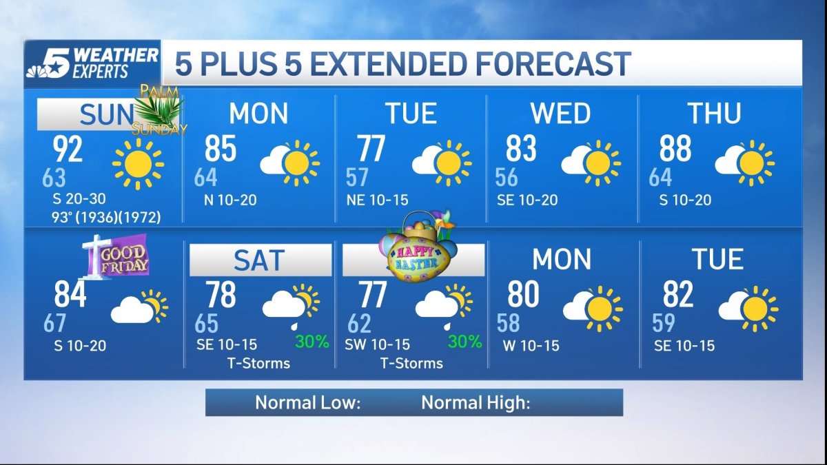
Sunday will feature near-record warmth, as temperatures soar into the low 90s. The record high for Sunday at DFW Airport is 93, last set in 1972. Some spots west of the Metroplex could get close to 100 degrees.
A wind advisory is in effect for North Texas, including Dallas and Fort Worth, from 9 a.m. until 7 p.m. Sunday. Winds could gust as high as 40 mph.
Watch NBC 5 free wherever you are

A cold front arriving Monday will bring slighter cooler temperatures by Tuesday as highs return to the 70s.
The upper-level jet stream will become a bit more active by Friday. This means showers and thunderstorms will return for Easter weekend. Stay tuned!
Get top local stories in DFW delivered to you every morning with NBC DFW's News Headlines newsletter.

Weather Experts


Latest Forecast:
SUNDAY: Sunny and windy with near record warmth. High: 92. Wind: S 20-30 mph with higher gusts.
TONIGHT: Clear and breezy. Low: 64. Wind: S 15-20 mph with higher gusts.
MONDAY: Partly sunny, breezy and warm. High: 85. Wind: N 10-20 mph with higher gusts.
TUESDAY: Sun, clouds and slightly cooler. Low: 57. High: 77. Wind: NE 10-15 mph.
WEDNESDAY: Mostly sunny, breezy and warm. Low: 56. High: 83. Wind: SE 10-20 mph with higher gusts.
THURSDAY: Sun, clouds, breezy and very warm. Low: 64. High: 88. Wind: S 10-20 mph with higher gusts.
FRIDAY: Mostly cloudy, breezy and warm. Low: 67. High: 84. Wind: S 10-20 mph with higher gusts.
SATURDAY: Mostly cloudy with a 30% chance of showers and storms. Low: 65. High: 78. Wind: SE 10-15 mph.
EASTER SUNDAY: Mostly cloudy with a 30% chance of showers and storms. Low: 62. High: 77. Wind: SW 10-15 mph.
MONDAY: Partly cloudy and warm. Low: 58. High: 80. Wind: W 10-15 mph.
TUESDAY: Partly sunny and warm. Low: 59. High: 82. Wind: SE 10-15 mph.
Click here to see all North Texas weather alerts
