
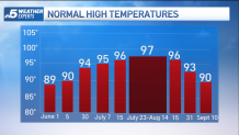
As we reach the statistical peak of summer heat in North Texas we will undergo a stretch of cooler-than-normal weather. The normal high from July 23 through August 14th is 97 degrees. This is the hottest normal high temperature we see all year.
The Climate Prediction Center has forecasted that North Texas will experience below-normal temperatures through at least August 2nd.
High temperatures through next week will be in the upper 80s and low 90s. North Texas has seen some good rain this week and more is coming into early next week.
Get top local stories in DFW delivered to you every morning. Sign up for NBC DFW's News Headlines newsletter.

Sunday through Wednesday offer a good chance for rain and thunderstorms. The threat of severe weather is low, but a few storms may produce some gusty winds and locally heavy rainfall. Rainfall totals over the next five days will be highest south of I-20 with some areas picking up over 2 inches.

After a few stretches of unseasonably hot weather, DFW is starting to see a minor deficit in monthly rainfall amounts. This past spring was wetter than normal and DFW does have a surplus of rain for the year.

This year we have received almost 30 inches of rain, over 7 inches more than normal.