North Texas

Threat of Storms Ends Thursday; Heat Advisory

Wednesday will be hot and muggy with chances of storms throughout the afternoon

S Band Radar & Maps | Forecast | Weather Alerts
Traffic | Send Us a Photo/Video | Live Cams

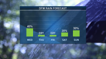
After a brief reprieve, North Texas is once again in an active weather pattern. Counties to the southeast of Dallas remain under a Severe Thunderstorm Watch until 6 a.m. Thursday morning.

Damaging wind gusts and large hail will be the main threats. Flooding rain may also take place.

Dry weather is expected Thursday and Friday. However the chance for storms returns to the forecast for the weekend into early next week.

Latest Video Forecast

The latest video forecast from NBC DFW's team of Weather Experts will appear in the player above. Keep up with the latest changes to the weather by downloading the NBC DFW smartphone App for iOS and Android!

Read the latest forecast information from NBC 5's team of Weather Experts here.

5-2-18 Tractor Trailer Loaded with Honey Bees on I-495
Virginia State Police
Stay Safe During a Hail Storm
 
At Home?
  • Head indoors immediately
  • If time allows, close all drapes, blinds or shades to prevent broken glass from entering your home.
  • Stay away from windows and skylights (any exterior glass) and head to a safe location inside your home, ideally only with interior walls.
Outdoors?
  • Cover your head and seek shelter indoors immediately.
  • If you are trapped outside, get to a low-lying area and try to protect your head. Use clothing if it all you have.
Driving?
  • Stay inside your vehicle.
  • Slow down or pull over and stop at a safe location. DO NOT stop under a highway overpass. You may be protecting your vehicle, but you could be forcing other people to stop behind you.
  • Turn your back to windows or cover yourself with a blanket, coat or spare clothing to protect yourself from breaking glass.
  • If you have a sunroof, try to find something to protect your head.


Contact Us